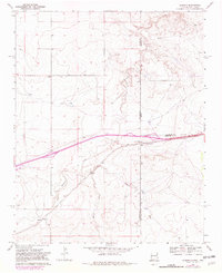
1968 Map of Glenrio
USGS Topo · Published 1982About this map
Glenrio straddles the border between New Mexico and Texas, serving as a primary focal point during this era of interstate travel before the full bypassing of old highway routes. The landscape is defined by the winding course of Trujillo Creek and Martha Creek, which carve through the high plains topography towards Sand Point Draw. Evidence of early settlement and community infrastructure is visible at Endee, where the Endee Cemetery preserves the local history of Quay County. This 1982 photorevised edition captures the evolution of transportation in the region, noting a Roadside Park near the state line and a major Pipeline cutting across the northern reaches of the quadrangle. The map highlights the intersection of four different counties—Quay, Oldham, Deaf Smith, and the state boundary itself—illustrating how political and geographical divisions meet in this arid corridor.
Find a feature on this map
12 named features on this map. Tap any name to fly to it.
Don’t see what you’re looking for? This feature index may not catch every label — zoom into the map to look around manually.
Map Details
Editions of this 1968 Glenrio Map
2 editions found
Other maps of this area

1954 · Tucumcari
USGS Topo · 1:250,000

1958 · Tucumcari
USGS Topo · 1:250,000

1966 · Moser Ranch
USGS Topo · 1:24,000

1966 · Signal Spring
USGS Topo · 1:24,000

1966 · Sand Point
USGS Topo · 1:24,000

1968 · Rock Camp
USGS Topo · 1:24,000

1968 · Blue Hole
USGS Topo · 1:24,000

1968 · Riley Camp
USGS Topo · 1:24,000

1968 · Bard
USGS Topo · 1:24,000

1968 · Glenrio
USGS Topo · 1:24,000