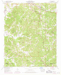
1950 Map of Glens
USGS Topo · Published 1971About this map
Tenn Valley Divide carves through this corner of northeast Mississippi, separating the drainage of Coke Creek and Hurricane Creek amidst a landscape of sharp ridges and winding hollows. The post office at Glen serves as a local hub along the Southern railroad line, while the historical village of Jacinto sits further south near the border of Alcorn and Prentiss Counties. This 1950s-era geography reflects a deeply rooted rural society defined by small churches and family burial grounds such as Kemp Chapel Cem and Indian Springs Church. The rugged topography is punctuated by prominent landmarks like Gobblers Knob and Bloodsaw Hill, while education centers like Glendale Sch and Hickory Flat School reveal the mid-century distribution of communities across these wooded hills before modern consolidation changed the rural character.
Find a feature on this map
94 named features on this map. Tap any name to fly to it.
Don’t see what you’re looking for? This feature index may not catch every label — zoom into the map to look around manually.
Map Details
Editions of this 1950 Glens Map
3 editions found

Other maps of this area

1921 · Booneville
USGS Topo · 1:48,000

1922 · Booneville
USGS Topo · 1:62,500

1935 · Holcut
USGS Topo · 1:24,000

1935 · Doskie
USGS Topo · 1:24,000

1935 · Leedy
USGS Topo · 1:24,000

1935 · Glens
USGS Topo · 1:24,000

1936 · Kendrick
USGS Topo · 1:24,000

1950 · Corinth
USGS Topo · 1:62,500

1950 · Kendrick
USGS Topo · 1:24,000

1950 · Paden
USGS Topo · 1:24,000