1946 Map of Glenville
USGS Topo · Published 1956About this map
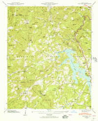
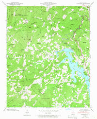
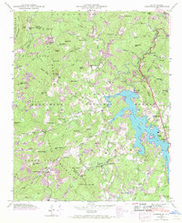
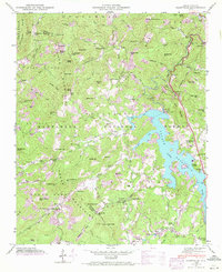
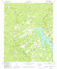
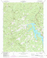
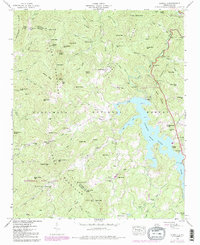
Glenville Lake and the Glenville Dam dominate this landscape, illustrating the mid-century infrastructure developments led by the Tennessee Valley Authority. Located at the boundary of Jackson and Macon counties, the map highlights rural life through vanished schoolhouses like Whiterock Sch and Double Spring Sch, alongside several family and community burial grounds including Strain Cem and Erastus Cem. The terrain is defined by the Cowee Mountains and Sugar Fork Mountains, while industrial sites such as the Power Plant and Surge Tank along the Tuckasegee River mark the era's energy production. Small settlements like Erastus, Bessie, and Norton are connected by forest roads and the Stewart Trail within the Nantahala National Forest.
Find a feature on this map
100 named features on this map. Tap any name to fly to it.
Don’t see what you’re looking for? This feature index may not catch every label — zoom into the map to look around manually.
Map Details
Editions of this 1946 Glenville Map
7 editions found
Other maps of this area

1891 · Cowee
USGS Topo · 1:125,000

1897 · Cowee
USGS Topo · 1:125,000

1907 · Cowee
USGS Topo · 1:125,000

1933 · Bryson
USGS Topo · 1:62,500

1935 · Cashiers
USGS Topo · 1:24,000

1935 · Tuckaseigee
USGS Topo · 1:24,000

1935 · Cullowhee
USGS Topo · 1:24,000

1935 · Scaly
USGS Topo · 1:24,000

1935 · Glenville
USGS Topo · 1:24,000

1935 · Corbin Knob
USGS Topo · 1:24,000