1946 Map of Glenville
USGS Topo · Published 1984About this map
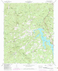
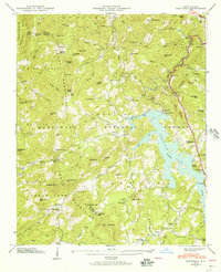
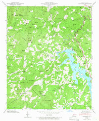
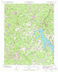
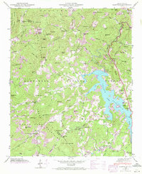
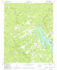
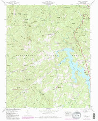
Thorpe Lake dominates the central landscape of this western North Carolina survey, its irregular shoreline reaching into the deep coves of the Nantahala National Forest. Created for hydroelectric power, the lake is anchored by the Thorpe Dam on the Tuckasegee River, with a notable Hydroelectric Tunnel and Power Plant downstream near Cedar Cliffs. The map captures a transition in the rural community, showing the settlement of Glenville on the eastern shore and Erastus to the west. Local genealogy is well-preserved through family and community landmarks, including the Erastus Cem, Strain Cem, and Norton Cem. Small mountain institutions like the Double Spring Sch and Yellow Mtn Ch are scattered among the high peaks of Yellow Mtn and Wolf Mountain, illustrating the high-altitude settlement patterns of the Cowee Mountains before modern development.
Find a feature on this map
117 named features on this map. Tap any name to fly to it.
Don’t see what you’re looking for? This feature index may not catch every label — zoom into the map to look around manually.
Map Details
Editions of this 1946 Glenville Map
7 editions found
Other maps of this area

1891 · Cowee
USGS Topo · 1:125,000

1897 · Cowee
USGS Topo · 1:125,000

1907 · Cowee
USGS Topo · 1:125,000

1933 · Bryson
USGS Topo · 1:62,500

1935 · Cashiers
USGS Topo · 1:24,000

1935 · Tuckaseigee
USGS Topo · 1:24,000

1935 · Cullowhee
USGS Topo · 1:24,000

1935 · Scaly
USGS Topo · 1:24,000

1935 · Glenville
USGS Topo · 1:24,000

1935 · Corbin Knob
USGS Topo · 1:24,000