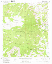
1965 Map of Glenwood
USGS Topo · Published 1979About this map
Glenwood serves as a small hub of activity in this 1960s survey of the western edge of the Gila National Forest. The settlement is defined by local infrastructure including the Glenwood Ranger Station, a State Fish Hatchery, and a Heliport, all situated along the eastern bank of the San Francisco River. The landscape transitions from the river valley into a complex network of canyons and high ridges, where water management is critical for ranching and forest maintenance. Numerous named livestock tanks, such as Roberts Park Tank and John Tank, are scattered across the high ground near Roberts Park Corral.
Find a feature on this map
126 named features on this map. Tap any name to fly to it.
Don’t see what you’re looking for? This feature index may not catch every label — zoom into the map to look around manually.
Map Details
Editions of this 1965 Glenwood Map
2 editions found
Other maps of this area

1910 · Mogollon
USGS Topo · 1:125,000

1912 · Mogollon
USGS Topo · 1:125,000

1913 · Morenci
USGS Topo · 1:125,000

1915 · Morenci
USGS Topo · 1:125,000

1954 · Clifton
USGS Topo · 1:250,000

1957 · Clifton
USGS Topo · 1:250,000

1958 · Clifton
USGS Topo · 1:250,000

1962 · Clifton
USGS Topo · 1:250,000

1962 · Big Lue Mts
USGS Topo · 1:62,500
1963 · Mogollon
USGS Topo · 1:24,000