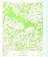
1960 Map of Glenwood
USGS Topo · Published 1978About this map
Indian Rock and the surrounding piney woods of East Texas are documented here during a period of significant mid-century change, where the traditional rural landscape meets the expanding footprint of the petroleum industry. The map captures the boundary between Upshur Co and Gregg Co, showcasing a network of small settlements like Glenwood and Graceton connected by a web of local roads and an Old Railroad Grade. This landscape is deeply rooted in its local institutions, evidenced by numerous community landmarks such as Pine Grove Tabernacle, New Bethlehem Sch, and Lake Providence Ch. The expansion of energy extraction is clearly visible in the East Texas Oil Field and the New Diana Oil Field to the east, illustrating the shift from purely agricultural pursuits to a resource-driven economy. Water features like Little Cypress Creek and Brawley Lake provide the natural structure for these communities and their local history.
Find a feature on this map
34 named features on this map. Tap any name to fly to it.
Don’t see what you’re looking for? This feature index may not catch every label — zoom into the map to look around manually.
Map Details
Editions of this 1960 Glenwood Map
2 editions found
Other maps of this area

1956 · Tyler
USGS Topo · 1:250,000

1960 · Bettie
USGS Topo · 1:24,000

1960 · White Oak
USGS Topo · 1:24,000

1960 · Gilmer
USGS Topo · 1:24,000

1960 · Coffeeville
USGS Topo · 1:24,000

1960 · Glenwood
USGS Topo · 1:24,000

1960 · Gladewater
USGS Topo · 1:24,000

1962 · Ashland
USGS Topo · 1:24,000

1962 · Longview Heights
USGS Topo · 1:24,000

1962 · Ore City
USGS Topo · 1:24,000