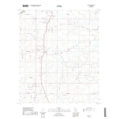
2018 Map of Gloster
USGS Topo · Published 2018About this map
Stonewall and the surrounding DeSoto Parish landscape are defined by a network of bayous and rural settlements as they appeared in the late 2010s. The area is anchored by the community of Gloster and the small crossroads of Kickapoo, with the Trinity Cem serving as a local genealogical landmark. This part of Louisiana's interior features a dense web of parish roads and family-named lanes that cut through a terrain drained by Sand Bayou, Edwards Bayou, and Caney Bayou. The presence of established parish boundaries and numerous named roads like Red Bluff Rd and Myrtle Hill Rd illustrates the long-standing land divisions in this region. Genealogists and local historians can use these contemporary surveys to identify modern access to older landmarks like Brinkley Pond or to trace property lines that have persisted since the early township and range surveys.
Find a feature on this map
90 named features on this map. Tap any name to fly to it.
Don’t see what you’re looking for? This feature index may not catch every label — zoom into the map to look around manually.
Map Details
Editions of this 2018 Gloster Map
This is the sole edition of this map. No revisions or reprints were ever made.
Other maps of this area
1945 · Grand Cane
USGS Topo · 1:62,500
1945 · Greenwood
USGS Topo · 1:62,500
1945 · Mansfield
USGS Topo · 1:62,500
1947 · Mansfield
USGS Topo · 1:62,500
1948 · Caspiana
USGS Topo · 1:62,500
1955 · Shreveport
USGS Topo · 1:250,000
1955 · Caspiana
USGS Topo · 1:62,500
1955 · Greenwood
USGS Topo · 1:62,500
1956 · Shreveport
USGS Topo · 1:250,000
1957 · Grand Cane
USGS Topo · 1:62,500