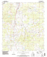
1994 Map of Gloster
USGS Topo · Published 1997About this map
Agricultural traditions and mid-century transitions define this area of the Caddo Parish and De Soto Parish border as it appeared in the 1990s. The landscape is notably anchored by large named estates such as Beauna Vista Plantation, Park Dots Plantation, and Roseneath Plantation, reflecting the deep-rooted land use patterns of the region. These holdings sit alongside smaller hubs like Gloster, Kickapoo, and Reeds Store, while modern development is represented by the Mobile Home Park near the northern boundary.
Find a feature on this map
20 named features on this map. Tap any name to fly to it.
Don’t see what you’re looking for? This feature index may not catch every label — zoom into the map to look around manually.
Map Details
Editions of this 1994 Gloster Map
This is the sole edition of this map. No revisions or reprints were ever made.
Other maps of this area

1945 · Grand Cane
USGS Topo · 1:62,500

1945 · Greenwood
USGS Topo · 1:62,500

1945 · Mansfield
USGS Topo · 1:62,500

1947 · Mansfield
USGS Topo · 1:62,500

1948 · Caspiana
USGS Topo · 1:62,500

1955 · Shreveport
USGS Topo · 1:250,000

1955 · Caspiana
USGS Topo · 1:62,500

1955 · Greenwood
USGS Topo · 1:62,500

1956 · Shreveport
USGS Topo · 1:250,000
1957 · Grand Cane
USGS Topo · 1:62,500