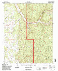
1995 Map of Gobernador
USGS Topo · Published 1997About this map
The high mesa country of Rio Arriba County is defined here by the deep incisions of Jara Canyon and Vaqueros Canyon, where the landscape transitions into the Carson National Forest. At the center of the map lies the Gobernador (Site), a location marked by a network of energy infrastructure, including an extensive Pipeline system and numerous gas wells. This industrial layer sits atop a traditional ranching landscape, evidenced by the Bissell Arnold Ranch and the small settlements of Snyder and Muñoz.
Find a feature on this map
41 named features on this map. Tap any name to fly to it.
Don’t see what you’re looking for? This feature index may not catch every label — zoom into the map to look around manually.
Map Details
Editions of this 1995 Gobernador Map
This is the sole edition of this map. No revisions or reprints were ever made.
Other maps of this area

1889 · Largo
USGS Topo · 1:250,000

1895 · Largo
USGS Topo · 1:250,000

1954 · Gomez Ranch
USGS Topo · 1:24,000

1954 · Aztec
USGS Topo · 1:250,000

1958 · Aztec
USGS Topo · 1:250,000

1962 · Aztec
USGS Topo · 1:250,000

1963 · Fourmile Canyon
USGS Topo · 1:24,000
1963 · Espinosa Ranch
USGS Topo · 1:24,000

1963 · Gobernador
USGS Topo · 1:24,000
1963 · Pine Lake
USGS Topo · 1:24,000