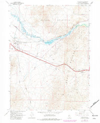
1965 Map of Golconda
USGS Topo · Published 1981About this map
Golconda serves as the focal point of this Nevada landscape, where the Humboldt River winds through the valley between the Osgood Mountains and Edna Mountain. The settlement's identity is tied to its geothermal and industrial roots, marked by the presence of a Hot Spring and the Golconda Mine. Transport networks dominate the corridor, with the Western Pacific and Southern Pacific railroads following the river's path through Emigrant Canyon. The geography reflects a mid-century transition in regional transit, as the path of Interstate 80 climbs toward Golconda Summit. Resource extraction is evident throughout the terrain, indicated by various prospect sites and borrow pits that dot the slopes near Preble and along the seasonal drainage of Rock Creek.
Find a feature on this map
22 named features on this map. Tap any name to fly to it.
Don’t see what you’re looking for? This feature index may not catch every label — zoom into the map to look around manually.
Map Details
Editions of this 1965 Golconda Map
4 editions found
Other maps of this area

1882 · Paradise
USGS Topo · 1:250,000

1893 · Paradise
USGS Topo · 1:250,000

1932 · Sonoma Range
USGS Topo · 1:250,000

1939 · Sonoma Range
USGS Topo · 1:250,000

1945 · Osgood Mountains
USGS Topo · 1:62,500

1947 · Osgood Mountains
USGS Topo · 1:62,500

1955 · McDermitt
USGS Topo · 1:250,000

1955 · Winnemucca
USGS Topo · 1:250,000

1958 · Winnemucca
USGS Topo · 1:250,000

1958 · Winnemucca
USGS Topo · 1:62,500