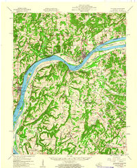
1959 Map of Golconda
USGS Topo · Published 1960About this map
Ohio River navigation and mining interests define this mid-century look at the border between Illinois and Kentucky. The river corridor is a hub of activity, anchored by the riverfront towns of Golconda, Rosiclare, and Elizabethtown, while Lock and Dam No 51 facilitates the heavy traffic of the day. Inland, the extraction of minerals is evident in the presence of the Empire Gem Mine, Bonanza Mines, and the Austin Mine north of the river, highlighting the area's geological importance to the industrial economy.
Find a feature on this map
84 named features on this map. Tap any name to fly to it.
Don’t see what you’re looking for? This feature index may not catch every label — zoom into the map to look around manually.
Map Details
Editions of this 1959 Golconda Map
2 editions found
Other maps of this area

1916 · Shawneetown
USGS Topo · 1:62,500

1916 · Fords Ferry
USGS Topo · 1:62,500

1916 · Golconda
USGS Topo · 1:62,500

1916 · Equality
USGS Topo · 1:62,500

1917 · Brownfield
USGS Topo · 1:62,500

1920 · Goloonda
USGS Topo · 1:48,000

1921 · Fords Ferry
USGS Topo · 1:48,000

1921 · Golconda
USGS Topo · 1:62,500

1925 · Harrisburg
USGS Topo · 1:62,500

1925 · Cave In Rock
USGS Topo · 1:62,500