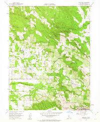
1954 Map of Gold Hill
USGS Topo · Published 1963About this map
Coon Canal and Southern Pacific rail lines define the hydraulic and commercial landscape of this Placer County region during the mid-1950s. The terrain is marked by the heavy hand of California's gold-rush legacy, evidenced by extensive Dredge Tailings along the Lincoln Road corridor and numerous ravine-cut drainages like Doty Ravine and Dutch Ravine. Community life is anchored by local institutions such as the Mt Pleasant Community Hall and the Gold Hill Grange Hall, while the educational landscape shows signs of transition with both the Gold Hill Sch (Abandoned) and Columbia Sch (Abandoned) marked as defunct. From the heights of Big Hill to the mineral waters at Kilaga Springs, the map reveals a countryside where early resource extraction and small-scale agriculture had already begun to leave a permanent mark on the land.
Find a feature on this map
29 named features on this map. Tap any name to fly to it.
Don’t see what you’re looking for? This feature index may not catch every label — zoom into the map to look around manually.
Map Details
Editions of this 1954 Gold Hill Map
4 editions found
Other maps of this area

1888 · Smartsville
USGS Topo · 1:125,000

1891 · Sacramento
USGS Topo · 1:125,000

1891 · Smartsville
USGS Topo · 1:125,000

1892 · Sacramento
USGS Topo · 1:125,000

1892 · Smartsville
USGS Topo · 1:125,000

1893 · Sacramento
USGS Topo · 1:125,000

1894 · Smartsville
USGS Topo · 1:125,000

1895 · Smartsville
USGS Topo · 1:125,000

1910 · Lincoln
USGS Topo · 1:31,680

1910 · Roseville
USGS Topo · 1:31,680