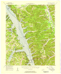
1955 Map of Golden Pond
USGS Topo · Published 1957About this map
Kentucky Lake dominates this mid-century landscape, representing the massive hydrological changes brought to the region by the Tennessee Valley Authority. This survey documents the area between the Tennessee River and the Cumberland River during a period of transition, showing the extensive Kentucky Woodlands Wildlife Refuge before it became part of the Land Between the Lakes National Recreation Area. Industrial history is etched into the terrain at Star Lime Works and the industrial remnants of Center Furnace (Ruins) and Mammoth Furnace. For genealogists, the map preserves the locations of numerous family and community landmarks, including the Birmingham Cem—a namesake of the community inundated by the lake—and rural congregations like Paradise Ch and Woodson Chapel. Small settlements such as Golden Pond and Aurora are shown connected by the Eggner Ferry Bridge, providing a detailed look at the road network and community hubs of the 1950s.
Find a feature on this map
113 named features on this map. Tap any name to fly to it.
Don’t see what you’re looking for? This feature index may not catch every label — zoom into the map to look around manually.
Map Details
Editions of this 1955 Golden Pond Map
This is the sole edition of this map. No revisions or reprints were ever made.
Other maps of this area

1908 · Princeton
USGS Topo · 1:62,500

1910 · Princeton
USGS Topo · 1:62,500

1928 · Eddyville
USGS Topo · 1:48,000

1929 · Smithland
USGS Topo · 1:62,500

1931 · Eddyville
USGS Topo · 1:62,500

1936 · Eddyville
USGS Topo · 1:48,000

1936 · Mont
USGS Topo · 1:24,000

1936 · Fenton
USGS Topo · 1:24,000

1936 · Grand Rivers
USGS Topo · 1:24,000

1936 · Hardin
USGS Topo · 1:24,000