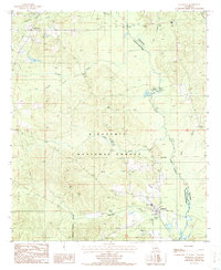
1986 Map of Goldonna
USGS Topo · Published 1986About this map
Goldonna and the northern reaches of the Kisatchie National Forest anchor this mid-1980s survey of the north-central Louisiana landscape. The terrain is defined by a dense network of waterways, including the winding Saline Bayou which serves as a natural boundary, and numerous tributaries such as Choctaw Creek, Malaudos Creek, and Eightmile Creek. The village of Goldonna is shown with its corporate boundary, while the smaller settlement of Readheimer appears to the northwest near Pine Ridge. Cultural and recreational development is concentrated near the water, evidenced by the Fish Hatchery and a Picnic Area & Campground complete with a Boat Ramp. Several Cem locations are noted across the quadrangle, providing valuable points of interest for genealogists and local historians studying the rural Natchitoches and Winn Parish borderlands.
Find a feature on this map
21 named features on this map. Tap any name to fly to it.
Don’t see what you’re looking for? This feature index may not catch every label — zoom into the map to look around manually.
Map Details
Editions of this 1986 Goldonna Map
This is the sole edition of this map. No revisions or reprints were ever made.
Other maps of this area

1937 · Campti NE
USGS Topo · 1:31,680

1944 · Campti
USGS Topo · 1:62,500

1947 · Goldonna
USGS Topo · 1:62,500

1947 · Ashland
USGS Topo · 1:62,500

1948 · Campti
USGS Topo · 1:62,500

1949 · Calvin NE
USGS Topo · 1:31,680

1949 · Calvin NW
USGS Topo · 1:31,680

1953 · Alexandria
USGS Topo · 1:250,000

1955 · Shreveport
USGS Topo · 1:250,000

1955 · Alexandria
USGS Topo · 1:250,000