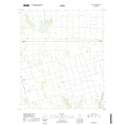
2019 Map of Gooch Lake
USGS Topo · Published 2019About this map
The boundary between Lynn and Dawson counties bisects this High Plains landscape, where agricultural grids are punctuated by significant playa basins. Gooch Lake and its neighbor Saleh Lake dominate the northern terrain, serving as vital topographic markers in an area defined by large-scale farming and ranching. The road network reflects a late-twentieth-century evolution of rural transit, ranging from local county routes like Co Rd 36 to more modern thoroughfares such as FM 2053 and Ranch Rd 1066. Near the western edge, the settlement of Grandview sits along Ranch Rd 179, illustrating the persistent, sparse residential pattern of the Texas South Plains. This era of mapping documents the region's sophisticated irrigation and road infrastructure that supports its industrial-scale cotton and grain production.
Find a feature on this map
23 named features on this map. Tap any name to fly to it.
Don’t see what you’re looking for? This feature index may not catch every label — zoom into the map to look around manually.
Map Details
Editions of this 2019 Gooch Lake Map
This is the sole edition of this map. No revisions or reprints were ever made.
Other maps of this area

1954 · Lubbock
USGS Topo · 1:250,000

1954 · Hobbs
USGS Topo · 1:250,000

1954 · Big Spring
USGS Topo · 1:250,000

1954 · Brownfield
USGS Topo · 1:250,000

1958 · Brownfield
USGS Topo · 1:250,000

1958 · Big Spring
USGS Topo · 1:250,000

1958 · Hobbs
USGS Topo · 1:250,000

1962 · Brownfield
USGS Topo · 1:250,000
1968 · Lamesa North
USGS Topo · 1:24,000
1968 · Hancock
USGS Topo · 1:24,000