1979 Map of Goochland
USGS Topo · Published 1982About this map
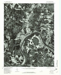
Goochland serves as the focal point of this 1979 orthophotoquad, situated along the northern bank of a deep bend in the James River. The aerial perspective reveals a landscape transitioning from the riverside bottomlands to a patchwork of agricultural clearings and dense woodland. To the west, the winding paths of Big Lickinghole Creek and Little Lickinghole Creek converge before meeting the river, carving distinct valleys through the terrain. Smaller rural settlements and crossroads like Dogtown, Three Square, and Michaux are visible as clusters of structures amidst the fields, illustrating the traditional Piedmont settlement patterns of the era. The imagery, rectified from 1979 photography by the U.S. Geological Survey and the Soil Conservation Service, captures the precise extent of land use, from the wooded heights of Cedar Point to the developed grounds of Beaumont.
Find a feature on this map
9 named features on this map. Tap any name to fly to it.
Don’t see what you’re looking for? This feature index may not catch every label — zoom into the map to look around manually.
Map Details
Editions of this 1979 Goochland Map
This is the sole edition of this map. No revisions or reprints were ever made.
Other maps of this area

1890 · Goochland
USGS Topo · 1:125,000

1891 · Palmyra
USGS Topo · 1:125,000

1892 · Goochland
USGS Topo · 1:125,000

1895 · Palmyra
USGS Topo · 1:125,000

1897 · Palmyra
USGS Topo · 1:125,000

1943 · Goochland
USGS Topo · 1:31,680

1943 · Fine Creek Mills
USGS Topo · 1:31,680

1943 · Powhatan
USGS Topo · 1:31,680

1943 · Perkinsville
USGS Topo · 1:31,680

1943 · South Anna
USGS Topo · 1:24,000