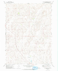
1972 Map of Good Hope Cemetery
USGS Topo · Published 1993About this map
Good Hope Cem serves as a lone landmark in this high plains landscape of western Nebraska, situated south of the dividing line between Township 16 North and Township 15 North. The map reveals a sparsely settled region defined by its natural drainage patterns, most notably the seasonal flow of Whitehorse Cr which winds through the southern portion of the quadrangle. For researchers of Lincoln County, the survey provides precise locations for remote homesteads and section roads as they existed in the early 1970s. The topographic detail highlights the subtle breaks and depressions of the sandhills region, illustrating how the environment dictated the placement of isolated rural infrastructure and water access points in this open ranching country.
Find a feature on this map
4 named features on this map. Tap any name to fly to it.
Don’t see what you’re looking for? This feature index may not catch every label — zoom into the map to look around manually.
Map Details
Editions of this 1972 Good Hope Cemetery Map
2 editions found
Other maps of this area

1899 · North Platte
USGS Topo · 1:125,000

1902 · North Platte
USGS Topo · 1:125,000

1954 · North Platte
USGS Topo · 1:250,000

1956 · North Platte
USGS Topo · 1:250,000

1957 · North Platte
USGS Topo · 1:250,000

1967 · North Platte
USGS Topo · 1:250,000

1970 · North Platte East
USGS Topo · 1:24,000

1970 · North Platte West
USGS Topo · 1:24,000
1970 · Hershey East
USGS Topo · 1:24,000
1972 · North Platte 2 SW
USGS Topo · 1:24,000