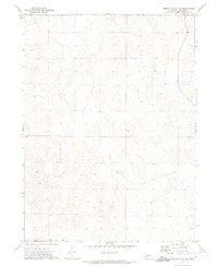
1972 Map of North Platte 2 SW
USGS Topo · Published 1975About this map
The Nebraska Sandhills terrain dominates this 1970s survey of the rural landscape south of the North Platte River. Characterized by a complex network of dunes and depressions, the area exhibits the subtle topographical variations of Range 31 and 32 West. While mostly open country, the tiny settlement of McNeel sits as a localized landmark within the sectioned grazing land. The map provides a meticulous record of section lines and range boundaries, such as the dividing line between Township 15 and 16 North, which were essential for land management and cattle ranching in Lincoln County during this era. This specific survey captures the region just as modern photogrammetric mapping techniques were becoming the standard for documenting the remote interior of the Great Plains.
Find a feature on this map
3 named features on this map. Tap any name to fly to it.
Don’t see what you’re looking for? This feature index may not catch every label — zoom into the map to look around manually.
Map Details
Editions of this 1972 North Platte 2 SW Map
2 editions found
Other maps of this area

1898 · Paxton
USGS Topo · 1:125,000

1899 · North Platte
USGS Topo · 1:125,000

1901 · Paxton
USGS Topo · 1:125,000

1902 · North Platte
USGS Topo · 1:125,000

1954 · North Platte
USGS Topo · 1:250,000

1956 · North Platte
USGS Topo · 1:250,000

1957 · North Platte
USGS Topo · 1:250,000

1967 · North Platte
USGS Topo · 1:250,000

1970 · North Platte West
USGS Topo · 1:24,000
1970 · Hershey East
USGS Topo · 1:24,000