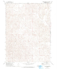
1972 Map of North Of Hershey
USGS Topo · Published 1993About this map
Sandhills terrain dominates this corner of Lincoln County, characterized by a complex network of dunes and depressions typical of the Nebraska prairie. Surveyed in the early 1970s, the map reveals a landscape defined by natural topography rather than human development, centered around the intersection of Township 16 North and Township 15 North. The absence of named settlements, roads, or structures on this specific sheet highlights the rural isolation and purely agricultural character of the region during this era. Land use is organized by the Public Land Survey System, with the boundary between Range 32 West and Range 31 West marking the primary north-south divide. This survey provides a baseline of the mid-century Nebraska landscape before contemporary changes in land management or irrigation practices altered the surface profile of the hills.
Find a feature on this map
2 named features on this map. Tap any name to fly to it.
Don’t see what you’re looking for? This feature index may not catch every label — zoom into the map to look around manually.
Map Details
Editions of this 1972 North Of Hershey Map
2 editions found
Other maps of this area

1898 · Paxton
USGS Topo · 1:125,000

1899 · North Platte
USGS Topo · 1:125,000

1901 · Paxton
USGS Topo · 1:125,000

1902 · North Platte
USGS Topo · 1:125,000

1954 · North Platte
USGS Topo · 1:250,000

1956 · North Platte
USGS Topo · 1:250,000

1957 · North Platte
USGS Topo · 1:250,000

1967 · North Platte
USGS Topo · 1:250,000

1970 · North Platte West
USGS Topo · 1:24,000
1970 · Hershey East
USGS Topo · 1:24,000