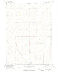
1972 Map of North Platte 2 SE
USGS Topo · Published 1975About this map
Good Hope Cem stands as a primary genealogical landmark in this Lincoln County landscape, situated amidst the complex terrain of the Nebraska Sandhills. This 1972 survey records a region defined by its sparse settlement and the winding path of Whitehorse Cr, which drains the southern portion of the quadrangle. The map details the transition between township and range lines, specifically marking the boundaries of T. 16 N. T. 15 N. and R. 31 W. R. 30 W.. The intricate contour work illustrates the characteristic dune topography of the area, providing a precise look at the land forms before more modern developments. This sheet is particularly useful for those tracing family ties to the rural cemeteries or studying the hydrology of the Platte River valley periphery.
Find a feature on this map
4 named features on this map. Tap any name to fly to it.
Don’t see what you’re looking for? This feature index may not catch every label — zoom into the map to look around manually.
Map Details
Editions of this 1972 North Platte 2 SE Map
2 editions found
Other maps of this area

1899 · North Platte
USGS Topo · 1:125,000

1902 · North Platte
USGS Topo · 1:125,000

1954 · North Platte
USGS Topo · 1:250,000

1956 · North Platte
USGS Topo · 1:250,000

1957 · North Platte
USGS Topo · 1:250,000

1967 · North Platte
USGS Topo · 1:250,000

1970 · North Platte East
USGS Topo · 1:24,000

1970 · North Platte West
USGS Topo · 1:24,000
1970 · Hershey East
USGS Topo · 1:24,000
1972 · North Platte 2 SW
USGS Topo · 1:24,000