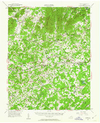
1950 Map of Goode
USGS Topo · Published 1962About this map
Jefferson National Forest dominates the northwestern corner of this mid-century topographic survey, where the peaks of Suck Mtn and Flint Stone Mtn rise above the James River valley. The landscape transitions from these steep ridges into a dense network of small farming communities and industrial corridors defined by the Norfolk and Western and Southern railroads. The presence of Poplar Forest and the New London Academy highlights the area's deep educational and residential roots, while numerous rural institutions like Mt Herman Ch and Hutter Sch underscore the social fabric of the era. The terrain is deeply incised by waterways such as the Big Otter River and Elk Creek, which historically supported early industry at sites like Coltons Mill. This survey captures a moment when traditional rural life, centered around crossroads like Goode and Lowry, remained clearly defined against the backdrop of the Blue Ridge foothills.
Find a feature on this map
93 named features on this map. Tap any name to fly to it.
Don’t see what you’re looking for? This feature index may not catch every label — zoom into the map to look around manually.
Map Details
Editions of this 1950 Goode Map
3 editions found

Other maps of this area

1890 · Roanoke
USGS Topo · 1:125,000

1891 · Roanoke
USGS Topo · 1:125,000

1892 · Lynchburg
USGS Topo · 1:125,000

1894 · Natural Bridge
USGS Topo · 1:125,000

1894 · Lexington
USGS Topo · 1:125,000

1894 · Natural Bridge
USGS Topo · 1:62,500

1907 · Natural Bridge Special
USGS Topo · 1:62,500

1935 · Buena Vista
USGS Topo · 1:48,000

1935 · Amherst
USGS Topo · 1:48,000

1939 · Amherst
USGS Topo · 1:62,500