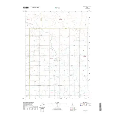
2020 Map of Gooding SE
USGS Topo · Published 2020About this map
U Canal and S Canal anchor an intricate lattice of irrigation infrastructure that defines the agricultural landscape of this region where Gooding, Lincoln, and Jerome Counties meet. The geometric precision of the grid-based road system, including Three Mile Wendell Rd, W 500 N, and E 700 N, reveals the systematic division of the land for cultivation. This network of water management, featuring dozens of named laterals such as Lateral U-12, Lateral R-11, and Lateral W-1, illustrates the human engineering required to transform the high desert into productive farmland. The proximity of the Gooding and Lincoln County line to these watercourses shows how irrigation development often followed or preceded political boundaries in the Snake River Plain's history.
Find a feature on this map
55 named features on this map. Tap any name to fly to it.
Don’t see what you’re looking for? This feature index may not catch every label — zoom into the map to look around manually.
Map Details
Editions of this 2020 Gooding SE Map
This is the sole edition of this map. No revisions or reprints were ever made.
Other maps of this area

1950 · Niagara Springs
USGS Topo · 1:24,000

1950 · Jerome
USGS Topo · 1:24,000

1950 · Jerome
USGS Topo · 1:62,500

1955 · Twin Falls
USGS Topo · 1:250,000

1958 · Twin Falls
USGS Topo · 1:250,000

1964 · Falls City
USGS Topo · 1:24,000
1971 · Wendell
USGS Topo · 1:24,000

1971 · Tunupa
USGS Topo · 1:24,000
1971 · Gooding SE
USGS Topo · 1:24,000
1971 · Gooding
USGS Topo · 1:24,000