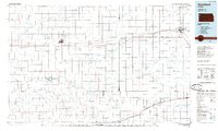
1985 Map of Goodland
USGS Topo · Published 1985About this map
The High Plains of Western Kansas are defined here by a network of dendritic drainage patterns and a strictly geometric road grid, centered on the hub of Goodland in Sherman County. The transportation corridor follows the path of the Union Pacific and Kyle railroads, linking the grain-handling settlements of Ruleton, Caruso, Edson, and Brewster. This era of mapping shows the region's transition into modern aviation and infrastructure, with several facilities including Renner Field and Hutton Airport serving the expansive agricultural landscape.
Find a feature on this map
49 named features on this map. Tap any name to fly to it.
Don’t see what you’re looking for? This feature index may not catch every label — zoom into the map to look around manually.
Map Details
Editions of this 1985 Goodland Map
2 editions found
Other maps of this area

1892 · Cheyenne Wells
USGS Topo · 1:125,000

1894 · Cheyenne Wells
USGS Topo · 1:125,000

1943 · Colby
USGS Topo · 1:62,500

1950 · Bonny Reservoir
USGS Topo · 1:62,500

1951 · Bird City South
USGS Topo · 1:62,500

1951 · Achilles
USGS Topo · 1:62,500

1951 · Chardon
USGS Topo · 1:62,500

1951 · Dewey Ranch
USGS Topo · 1:62,500

1952 · St Francis 3
USGS Topo · 1:62,500

1954 · Limon
USGS Topo · 1:250,000