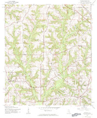
1960 Map of Goodman
USGS Topo · Published 1963About this map
Goodman and Battens Crossroads anchor this rural Coffee County landscape, which was meticulously field-checked just before the mid-century's end. The terrain is defined by the winding paths of Double Bridges Creek and its many tributaries like Whisky Branch and Blanket Creek. A mix of spiritual and community life is evident in the dense distribution of country churches, including Morning Star Ch and Pleasant Ridge Ch, which sit alongside family-named landmarks like Wooten Chapel.
Find a feature on this map
31 named features on this map. Tap any name to fly to it.
Don’t see what you’re looking for? This feature index may not catch every label — zoom into the map to look around manually.
Map Details
Editions of this 1960 Goodman Map
2 editions found
Other maps of this area

1942 · Enterprise
USGS Topo · 1:125,000

1950 · Enterprise
USGS Topo · 1:62,500

1953 · Andalusia
USGS Topo · 1:250,000

1953 · Dothan
USGS Topo · 1:250,000

1954 · Dothan
USGS Topo · 1:250,000

1955 · Dothan
USGS Topo · 1:250,000

1957 · Andalusia
USGS Topo · 1:250,000

1957 · Geneva
USGS Topo · 1:62,500

1957 · Bellwood
USGS Topo · 1:24,000
1957 · Coffee Springs
USGS Topo · 1:24,000