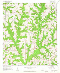
1960 Map of Goodman
USGS Topo · Published 1963About this map
Goodman and its rural environs in Coffee County are defined by a network of small family-owned farms and country churches during the mid-century. The landscape is carved by the winding paths of Double Bridges Creek and its tributaries, including Whisky Branch and Little Double Bridges Creek. These waterways dictate the settlement patterns, with rural hubs like Turner Crossroads and Battens Crossroads serving as navigational anchors for the local community. The mapping reveals a transition toward modern infrastructure, evidenced by the Enterprise Municipal Airport and a nearby Drive-in Theater, juxtaposed against older landmarks like Wooten Chapel and Bethany Ch. For genealogists, the numerous cemeteries and churches, such as Meadow Lawn Memorial Park and Morning Star Ch, offer precise locations for family history research. The Atlantic Coast Line railroad skirts the northeastern corner, indicating the vital rail links that connected this agricultural region to larger trade centers.
Find a feature on this map
33 named features on this map. Tap any name to fly to it.
Don’t see what you’re looking for? This feature index may not catch every label — zoom into the map to look around manually.
Map Details
Editions of this 1960 Goodman Map
2 editions found
Other maps of this area

1942 · Enterprise
USGS Topo · 1:125,000

1950 · Enterprise
USGS Topo · 1:62,500

1953 · Andalusia
USGS Topo · 1:250,000

1953 · Dothan
USGS Topo · 1:250,000

1954 · Dothan
USGS Topo · 1:250,000

1955 · Dothan
USGS Topo · 1:250,000

1957 · Andalusia
USGS Topo · 1:250,000

1957 · Geneva
USGS Topo · 1:62,500

1957 · Bellwood
USGS Topo · 1:24,000
1957 · Coffee Springs
USGS Topo · 1:24,000