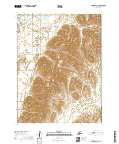
2019 Map of Goodnews Bay A-2 SW
USGS Topo · Published 2019About this map
Klakak River winds through the northwestern corner of this remote Alaskan landscape, which is characterized by dramatic elevation changes and sparse naming. The terrain is defined by its drainage patterns, with Tithe Cr appearing in the eastern reaches, marking the subtle flow of water through the wilderness of the Dillingham Census Area. This 2019 survey documents a landscape nearly untouched by modern infrastructure, lacking any labeled roads or settlements. Instead, the map provides a clear picture of the raw topography and the historical land divisions across four townships, including t13s r62w and t12s r61w. This type of survey is essential for understanding the physical barriers and natural corridors that have dictated movement in this part of Alaska for generations.
Find a feature on this map
6 named features on this map. Tap any name to fly to it.
Don’t see what you’re looking for? This feature index may not catch every label — zoom into the map to look around manually.
Map Details
Editions of this 2019 Goodnews Bay A-2 SW Map
This is the sole edition of this map. No revisions or reprints were ever made.
Other maps of this area

1945 · Nushagak Bay
USGS Topo · 1:250,000

1949 · Nushagak Bay
USGS Topo · 1:250,000

1950 · Nushagak Bay D-5
USGS Topo · 1:63,360

1950 · Nushagak Bay D-6
USGS Topo · 1:63,360

1951 · Goodnews
USGS Topo · 1:250,000

1951 · Nushagak Bay
USGS Topo · 1:250,000

1954 · Goodnews A-3
USGS Topo · 1:63,360

1964 · Nushagak Bay
USGS Topo · 1:250,000

1979 · Goodnews Bay
USGS Topo · 1:250,000
1979 · Goodnews Bay A-2
USGS Topo · 1:63,360