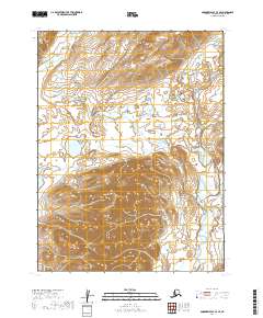
2019 Map of Goodnews Bay A-3 SE
USGS Topo · Published 2019About this map
The Kulukak River meanders through this portion of the Dillingham Census Area, defining the eastern drainage of the local landscape. In the northwest, the Ugalikthluk River flows through a series of wetlands and low-lying areas, illustrating the hydrologic patterns of the Bristol Bay region. This map provides a detailed view of the terrain within the t12s r63w and t13s r63w townships, showing the significant elevation changes between the river valleys and the upland ridges. The absence of roads or permanent settlements highlighted on the sheet emphasizes the remote and natural state of this Alaskan wilderness as it was documented in the late 2010s.
Find a feature on this map
6 named features on this map. Tap any name to fly to it.
Don’t see what you’re looking for? This feature index may not catch every label — zoom into the map to look around manually.
Map Details
Editions of this 2019 Goodnews Bay A-3 SE Map
This is the sole edition of this map. No revisions or reprints were ever made.
Other maps of this area

1945 · Nushagak Bay
USGS Topo · 1:250,000

1949 · Nushagak Bay
USGS Topo · 1:250,000

1950 · Nushagak Bay D-6
USGS Topo · 1:63,360

1951 · Goodnews
USGS Topo · 1:250,000

1951 · Nushagak Bay
USGS Topo · 1:250,000

1954 · Goodnews A-3
USGS Topo · 1:63,360

1964 · Nushagak Bay
USGS Topo · 1:250,000

1979 · Goodnews Bay
USGS Topo · 1:250,000
1979 · Goodnews Bay A-2
USGS Topo · 1:63,360
2019 · Nushagak Bay D-6 NE
USGS Topo · 1:25,000