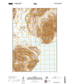
2019 Map of Nushagak Bay D-6 NE
USGS Topo · Published 2019About this map
The Kulukak River defines the drainage of this coastal landscape as it meanders through a network of wetlands toward the southern coast. This area of Southwest Alaska is characterized by significant topographical relief, with hills rising sharply above the expansive marshes and river plains. The land meets the sea at Bristol Bay, where the coastline curves into the sheltered waters of Kulukak Bay. This 2019 survey documents the intricate hydrologic patterns of the region, showing how the river system interacts with the tidal influence of the bay. The map illustrates the uninhabited nature of this terrain, where the primary features are the natural waterways and the elevation contours that shape the remote peninsula.
Find a feature on this map
8 named features on this map. Tap any name to fly to it.
Don’t see what you’re looking for? This feature index may not catch every label — zoom into the map to look around manually.
Map Details
Editions of this 2019 Nushagak Bay D-6 NE Map
This is the sole edition of this map. No revisions or reprints were ever made.
Other maps of this area

1945 · Nushagak Bay
USGS Topo · 1:250,000

1949 · Nushagak Bay
USGS Topo · 1:250,000

1950 · Nushagak Bay D-5
USGS Topo · 1:63,360

1950 · Nushagak Bay D-6
USGS Topo · 1:63,360

1951 · Goodnews
USGS Topo · 1:250,000

1951 · Nushagak Bay
USGS Topo · 1:250,000

1954 · Goodnews A-3
USGS Topo · 1:63,360

1964 · Nushagak Bay
USGS Topo · 1:250,000

1979 · Goodnews Bay
USGS Topo · 1:250,000
1979 · Goodnews Bay A-2
USGS Topo · 1:63,360