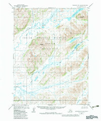
1979 Map of Goodnews Bay B-5
USGS Topo · Published 1983About this map
Togiak National Wildlife Refuge and the Togiak Wilderness encompass this Alaskan landscape, defined by a complex network of glacial rivers and peaks. The drainage system is anchored by the Goodnews River and the Kukaktlik River, which weave through a terrain dominated by Nagyagat Mountain and Unglueyagat Mountain. This 1979 survey reflects the region's status following the Alaska National Interest Lands Conservation Act, documenting a protected wilderness without established roads or trails. Smaller tributaries like Nimgun Creek and Awayak Creek feed into the larger river systems, while Goodnews Lake marks a significant water body in the northeastern corner. The map provides a detailed view of the natural hydrology and topographical contours prior to the 1983 publication, showing the remote character of the Quigmy River valley and the Middle Fork Goodnews River.
Find a feature on this map
13 named features on this map. Tap any name to fly to it.
Don’t see what you’re looking for? This feature index may not catch every label — zoom into the map to look around manually.
Map Details
Editions of this 1979 Goodnews Bay B-5 Map
2 editions found
Other maps of this area

1951 · Goodnews
USGS Topo · 1:250,000

1954 · Goodnews C-4
USGS Topo · 1:63,360

1954 · Goodnews A-4
USGS Topo · 1:63,360

1954 · Goodnews A-6
USGS Topo · 1:63,360

1954 · Goodnews B-6
USGS Topo · 1:63,360

1954 · Goodnews C-6
USGS Topo · 1:63,360

1979 · Goodnews Bay C-5
USGS Topo · 1:63,360

1979 · Goodnews Bay A-5
USGS Topo · 1:63,360

1979 · Goodnews Bay B-5
USGS Topo · 1:63,360

1979 · Goodnews Bay
USGS Topo · 1:250,000