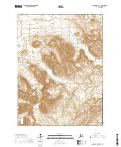
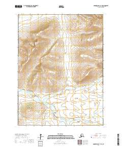
2017 Map of Goodnews Bay B-6 NW
USGS Topo · Published 2017About this map
Arolik Lake and the surrounding drainage basins of the Bethel Census Area define this interior Alaskan landscape. The terrain is characterized by a complex network of waterways, including the winding E Fork Arolik River and several significant tributaries such as Canyon Cr and Bear Cr. The topographic detail reveals a series of prominent peaks and ridgelines, most notably Kisogle Mtn in the southwest and Atlakumtsitak Mtn in the southeast. These natural landmarks serve as primary navigational points in an area otherwise defined by its hydrological patterns, including the elongated Canyon Lake. The survey provides a clear view of the land as it was documented in the early twenty-first century, showing the relationship between high-elevation ridges and the numerous creeks like Garnet Cr and Crater Cr that carve through the valleys.
Find a feature on this map
17 named features on this map. Tap any name to fly to it.
Don’t see what you’re looking for? This feature index may not catch every label — zoom into the map to look around manually.
Map Details
Editions of this 2017 Goodnews Bay B-6 NW Map
This is the sole edition of this map. No revisions or reprints were ever made.
Other maps of this area

1951 · Goodnews
USGS Topo · 1:250,000

1954 · Goodnews B-7
USGS Topo · 1:63,360

1954 · Goodnews C-7
USGS Topo · 1:63,360

1954 · Goodnews B-6
USGS Topo · 1:63,360

1954 · Goodnews C-6
USGS Topo · 1:63,360

1979 · Goodnews Bay
USGS Topo · 1:250,000
2017 · Goodnews Bay B-7 NE
USGS Topo · 1:25,000
2017 · Goodnews Bay C-6 SW
USGS Topo · 1:25,000
2017 · Goodnews Bay B-7 SE
USGS Topo · 1:25,000
2017 · Goodnews Bay C-7 SE
USGS Topo · 1:25,000