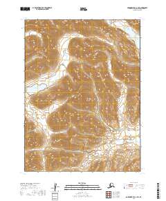
2019 Map of Goodnews Bay C-1 SW
USGS Topo · Published 2019About this map
Ongivinuk Lake and its corresponding Ongivinuk River dominate the western portion of this landscape, illustrating the complex hydrology of the Wood-Tikchik region. The terrain is characterized by high-elevation ridges that give way to the prominent Sunshine Valley in the south, where Sunshine Cr drains toward the lower basins. Along the eastern boundary, Little Togiak Lake sits at the edge of a mountain range, fed by the small Little Togiak Cr. The absence of man-made infrastructure or settlements underscores the untouched nature of this wilderness at the time of this 2019 survey, focusing instead on the drainage patterns and significant elevation changes between the valleys and peaks.
Find a feature on this map
12 named features on this map. Tap any name to fly to it.
Don’t see what you’re looking for? This feature index may not catch every label — zoom into the map to look around manually.
Map Details
Editions of this 2019 Goodnews Bay C-1 SW Map
This is the sole edition of this map. No revisions or reprints were ever made.
Other maps of this area

1951 · Goodnews
USGS Topo · 1:250,000

1954 · Goodnews C-2
USGS Topo · 1:63,360

1979 · Goodnews Bay B-2
USGS Topo · 1:63,360

1979 · Goodnews Bay B-1
USGS Topo · 1:63,360

1979 · Goodnews Bay
USGS Topo · 1:250,000

1979 · Goodnews Bay C-1
USGS Topo · 1:63,360

2019 · Goodnews Bay C-2 SE
USGS Topo · 1:25,000
2019 · Goodnews Bay B-2 NE
USGS Topo · 1:25,000
2019 · Goodnews Bay C-1 SE
USGS Topo · 1:25,000
2019 · Goodnews Bay C-2 NE
USGS Topo · 1:25,000