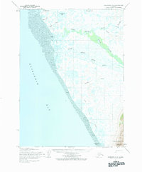
1954 Map of Goodnews C-8
USGS Topo · Published 1984About this map
Quinhagak sits at the northern edge of this coastal survey, where the rugged terrain of the Kuskokwim Delta meets the expansive Tidal Flat of Kuskokwim Bay. The landscape is dominated by a complex network of waterways, including the dual outlets of the North Mouth Arolik River and South Mouth Arolik River. To the south, the terrain rises toward the heights of North Yoke Mountain and South Yoke Mountain, overlooking Jacksmith Bay. Interior connectivity in this mid-century period relied heavily on seasonal routes, evidenced by the Winter Trail (Approx) that winds through a mosaic of small lakes and marshes, such as Tsingigkalik Lake and Ithagsutlek Lake. The map identifies Arolik (Abandoned), pointing to shifting settlement patterns along the coast during the early 1950s.
Find a feature on this map
19 named features on this map. Tap any name to fly to it.
Don’t see what you’re looking for? This feature index may not catch every label — zoom into the map to look around manually.
Map Details
Editions of this 1954 Goodnews C-8 Map
2 editions found
Other maps of this area

1951 · Kuskokwim Bay
USGS Topo · 1:250,000

1951 · Goodnews
USGS Topo · 1:250,000

1954 · Goodnews B-7
USGS Topo · 1:63,360

1954 · Kuskokwim Bay
USGS Topo · 1:250,000

1954 · Goodnews B-8
USGS Topo · 1:63,360

1954 · Goodnews C-7
USGS Topo · 1:63,360

1954 · Goodnews D-7
USGS Topo · 1:63,360
1954 · Goodnews D-8
USGS Topo · 1:63,360
1954 · Kuskokwim Bay D-1
USGS Topo · 1:63,360
1954 · Goodnews C-8
USGS Topo · 1:63,360