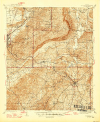
1947 Map of Goodwater
USGS Topo · Published 1947About this map
Hatchet Creek winds through the heart of the Talladega and Coosa county borderlands, defining a landscape where rural settlements and institutional landmarks follow the early twentieth-century rail corridors. The town of Goodwater serves as a significant hub in the southeast, where the Central of Georgia railroad facilitates local commerce. To the west, the industrial and transport footprint of Sylacauga is visible, while the interior is dotted with small communities like Hollins and Parkdale.
Find a feature on this map
60 named features on this map. Tap any name to fly to it.
Don’t see what you’re looking for? This feature index may not catch every label — zoom into the map to look around manually.
Map Details
Editions of this 1947 Goodwater Map
2 editions found

Other maps of this area

1890 · Talladega
USGS Topo · 1:125,000

1891 · Ashland
USGS Topo · 1:125,000

1892 · Talladega
USGS Topo · 1:125,000

1901 · Wetumpka
USGS Topo · 1:125,000

1903 · Wetumpka
USGS Topo · 1:125,000

1906 · Dadeville
USGS Topo · 1:125,000

1915 · Gantts Quarry
USGS Topo · 1:48,000

1917 · Gantts Quarry
USGS Topo · 1:62,500

1943 · Talladega
USGS Topo · 1:62,500

1944 · Goodwater
USGS Topo · 1:62,500