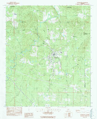
1987 Map of Goodwater
USGS Topo · Published 1987About this map
Goodwater serves as the central hub of this north-central Alabama landscape, situated where the Southern line passes through the county. The settlement is defined by local institutions like the Goodwater Academy and several long-standing burial grounds including Crestview Memorial Cem and Greenview Memorial Park. The topography is dominated by the winding path of Hatchet Creek and its many tributaries, such as Wildcat Creek and Partridge Creek, which carve through the rising elevations of Candler Mountain. In the rural stretches outside of town, smaller crossroads and communities like Skeggs Crossroads, Parkdale, and Soleo mark the transition toward the densely wooded boundaries of the Talladega National Forest. Traces of local industry appear in the south at a Rock Quarry near Baker Creek, while the presence of Marietta Ch and Smyrna Ch highlights the importance of country churches in the surrounding area.
Find a feature on this map
28 named features on this map. Tap any name to fly to it.
Don’t see what you’re looking for? This feature index may not catch every label — zoom into the map to look around manually.
Map Details
Editions of this 1987 Goodwater Map
This is the sole edition of this map. No revisions or reprints were ever made.
Other maps of this area

1890 · Talladega
USGS Topo · 1:125,000

1891 · Ashland
USGS Topo · 1:125,000

1892 · Talladega
USGS Topo · 1:125,000

1901 · Wetumpka
USGS Topo · 1:125,000

1903 · Wetumpka
USGS Topo · 1:125,000

1906 · Dadeville
USGS Topo · 1:125,000

1944 · Goodwater
USGS Topo · 1:62,500

1947 · Goodwater
USGS Topo · 1:62,500

1953 · Montgomery
USGS Topo · 1:250,000

1953 · Birmingham
USGS Topo · 1:250,000