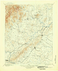
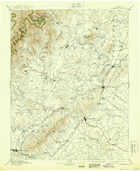
1892 Map of Gordonsville
USGS Topo · Published 1949About this map
Gordonsville and Orange serve as critical rail junctions in this late 19th-century landscape where the Virginia Midland Railroad and the Chesapeake and Ohio Railroad converge. The terrain is dominated by the prominent Southwestern Mountain ridge and the rising peaks of the Blue Ridge, including Doubletop Mountain and Fork Mountain within the northern reaches of what would become Shenandoah National Park. The map documents a dense network of river-valley settlements such as Criglersville along the Robertson River and Stanardsville near the Swift Run headwaters.
Find a feature on this map
80 named features on this map. Tap any name to fly to it.
Don’t see what you’re looking for? This feature index may not catch every label — zoom into the map to look around manually.
Map Details
Editions of this 1892 Gordonsville Map
6 editions found
Other maps of this area

1887 · Spottsylvania
USGS Topo · 1:125,000

1890 · Goochland
USGS Topo · 1:125,000

1891 · Palmyra
USGS Topo · 1:125,000

1892 · Buckingham
USGS Topo · 1:125,000

1892 · Spottsylvania
USGS Topo · 1:125,000

1892 · Goochland
USGS Topo · 1:125,000

1892 · Woodstock
USGS Topo · 1:125,000

1892 · Gordonsville
USGS Topo · 1:125,000

1892 · Harrisonburg
USGS Topo · 1:125,000

1893 · Luray
USGS Topo · 1:125,000