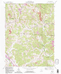
1992 Map of Gore
USGS Topo · Published 1995About this map
Monday Creek and its many tributaries carve through this pocket of the Wayne National Forest, revealing a landscape shaped by coal and iron history. The industrial heritage of the late nineteenth and early twentieth centuries is visible at sites like Bessie Furnace and the rail connections at Monday Creek Junction. Historical land divisions are clearly marked, including the Ohio Company Purchase and the South North Boundary 1777, which offer a window into early American surveying and westward expansion.
Find a feature on this map
44 named features on this map. Tap any name to fly to it.
Don’t see what you’re looking for? This feature index may not catch every label — zoom into the map to look around manually.
Map Details
Editions of this 1992 Gore Map
This is the sole edition of this map. No revisions or reprints were ever made.
Other maps of this area

1903 · Athens
USGS Topo · 1:62,500

1904 · Zaleski
USGS Topo · 1:62,500

1905 · Athens
USGS Topo · 1:62,500

1907 · Zaleski
USGS Topo · 1:62,500

1907 · Logan
USGS Topo · 1:62,500

1909 · Logan
USGS Topo · 1:62,500

1911 · New Lexington
USGS Topo · 1:62,500

1947 · Columbus
USGS Topo · 1:250,000

1961 · Columbus
USGS Topo · 1:250,000

1961 · Nelsonville
USGS Topo · 1:24,000