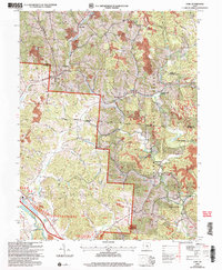
2002 Map of Gore
USGS Topo · Published 2006About this map
Wayne National Forest dominates this section of the Hocking Valley, where the terrain is marked by the legacy of early industrial extraction. Numerous quarries, a Strip Mine, and the historic Bessie Furnace near Oreville illustrate the region's reliance on coal and iron ore. The CSX Transportation line follows the winding course of Monday Creek, connecting small settlements like Monday Creek Junction and Sand Run Junction that once served as vital nodes in the local mineral economy. Local genealogy is anchored by family-named landmarks such as the Rhodes and Huddle Cem and Wells Chapel, providing specific points of reference for researchers tracing residents of vanished hamlets like Old Gore or Paine Crossing.
Find a feature on this map
58 named features on this map. Tap any name to fly to it.
Don’t see what you’re looking for? This feature index may not catch every label — zoom into the map to look around manually.
Map Details
Editions of this 2002 Gore Map
This is the sole edition of this map. No revisions or reprints were ever made.
Other maps of this area

1903 · Athens
USGS Topo · 1:62,500

1904 · Zaleski
USGS Topo · 1:62,500

1905 · Athens
USGS Topo · 1:62,500

1907 · Zaleski
USGS Topo · 1:62,500

1907 · Logan
USGS Topo · 1:62,500

1909 · Logan
USGS Topo · 1:62,500

1911 · New Lexington
USGS Topo · 1:62,500

1947 · Columbus
USGS Topo · 1:250,000

1961 · Columbus
USGS Topo · 1:250,000

1961 · Nelsonville
USGS Topo · 1:24,000