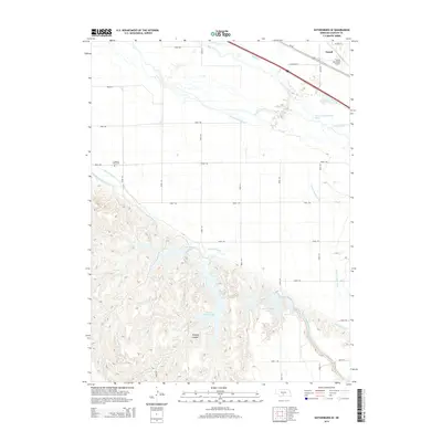
2014 Map of Gothenburg SE
USGS Topo · Published 2014About this map
Cozad sits at the northern edge of this landscape, where the flat agricultural plains of the Platte River valley meet a complex network of irrigation and water management. The Platte River and its North Channel dominate the northern corridor, flanked by the Cozad Municipal Airport and the historic Us-30 route. A sophisticated system of water engineering is visible through the Orchard Alfalfa Canal, Thirtymile Canal, and Tri-County Supply Canal, which carve through the terrain to support the region's farming economy.
Find a feature on this map
31 named features on this map. Tap any name to fly to it.
Don’t see what you’re looking for? This feature index may not catch every label — zoom into the map to look around manually.
Map Details
Editions of this 2014 Gothenburg SE Map
This is the sole edition of this map. No revisions or reprints were ever made.
Other maps of this area

1896 · Lexington
USGS Topo · 1:125,000

1899 · Lexington
USGS Topo · 1:125,000

1902 · Gothenburg
USGS Topo · 1:125,000

1954 · McCook
USGS Topo · 1:250,000

1955 · Grand Island
USGS Topo · 1:250,000

1957 · McCook
USGS Topo · 1:250,000

1957 · Grand Island
USGS Topo · 1:250,000

1958 · McCook
USGS Topo · 1:250,000

1958 · Grand Island
USGS Topo · 1:250,000
1970 · Gothenburg
USGS Topo · 1:24,000