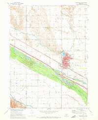
1970 Map of Gothenburg
USGS Topo · Published 1973About this map
The Platte River valley defines the landscape of this 1970 Nebraska survey, where the Gothenburg settlement thrives at the intersection of early irrigation infrastructure and major transportation corridors. The city grid, centered around Lafayette Park, is bounded by the Union Pacific railroad and a complex network of man-made waterways, including the Gothenburg Canal and Lake Helen. These features, alongside the Thirtymile Canal and Tri-County Supply Canal, illustrate the era's sophisticated water management efforts in the western plains. Outside the town center, the map records rural educational and religious landmarks such as School No 47, Christi Cem, and Peckham Cem, while industrial activity is noted via several Gravel Pits along the river's north channel. The Gothenburg Municipal Airport and a series of radio towers indicate the modernizing infrastructure of the mid-twentieth century.
Find a feature on this map
58 named features on this map. Tap any name to fly to it.
Don’t see what you’re looking for? This feature index may not catch every label — zoom into the map to look around manually.
Map Details
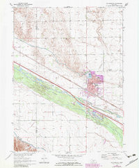
Editions of this 1970 Gothenburg Map
2 editions found
Other maps of this area

1902 · Gothenburg
USGS Topo · 1:125,000

1954 · McCook
USGS Topo · 1:250,000

1954 · North Platte
USGS Topo · 1:250,000

1956 · North Platte
USGS Topo · 1:250,000

1957 · North Platte
USGS Topo · 1:250,000

1957 · McCook
USGS Topo · 1:250,000

1958 · McCook
USGS Topo · 1:250,000

1967 · North Platte
USGS Topo · 1:250,000
1970 · Jeffrey Reservoir SE
USGS Topo · 1:24,000
1970 · Gothenburg SW
USGS Topo · 1:24,000