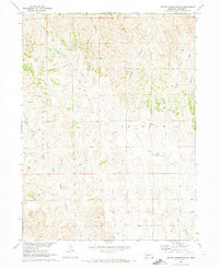
1970 Map of Jeffrey Reservoir SE
USGS Topo · Published 1973About this map
Peckham and the surrounding drainages of Lincoln County are captured in this 1970 survey, illustrating the complex hydrology of the Nebraska plains. The area is defined by a dense network of watercourses, most notably Plum Creek and its tributary, North Plum Creek, which wind through the terrain alongside East Deer Creek. These labels suggest a landscape shaped by intermittent water flow and cattle ranching during the late twentieth century. Numerous unnamed wells dot the land, particularly around the central plains of Peckham, indicating the critical importance of groundwater for agricultural survival in this semi-arid region. Several prominent geological features, including Gilman Canyon and Gulch Canyon, show how erosion has carved deep incisions into the plateau, creating a distinct pattern of land use focused on the valley floors.
Find a feature on this map
8 named features on this map. Tap any name to fly to it.
Don’t see what you’re looking for? This feature index may not catch every label — zoom into the map to look around manually.
Map Details
Editions of this 1970 Jeffrey Reservoir SE Map
This is the sole edition of this map. No revisions or reprints were ever made.
Other maps of this area

1902 · Gothenburg
USGS Topo · 1:125,000

1954 · McCook
USGS Topo · 1:250,000

1956 · Jeffrey Reservoir SW
USGS Topo · 1:24,000

1956 · Stockville NE
USGS Topo · 1:24,000

1956 · Moorefield
USGS Topo · 1:24,000

1957 · McCook
USGS Topo · 1:250,000

1958 · McCook
USGS Topo · 1:250,000
1970 · Gothenburg
USGS Topo · 1:24,000
1970 · Gothenburg SW
USGS Topo · 1:24,000
1970 · Jeffrey Reservoir
USGS Topo · 1:24,000