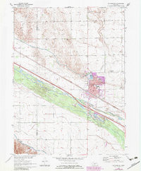
1970 Map of Gothenburg
USGS Topo · Published 1983About this map
Gothenburg serves as the focal point of this 1970s survey, positioned at a critical junction where the Union Pacific railroad parallels the broad course of the Platte River. The map illustrates a complex hydraulic landscape defined by the Gothenburg Canal, Sixmile Canal, and the Tri-County Supply Canal, reflecting the region's reliance on irrigation and water management. Within the city, localized features like Lake Helen and Lafayette Park provide recreation, while the High Sch and Hospital mark the community's essential infrastructure. North of the river, the terrain rises into Wild Horse Valley, contrasting with the level expanses of Quinn Field to the east. Several rural cemeteries, including Salem Cem and Peckham Cem, offer significant clues for genealogists researching families in the rural areas surrounding the Platte.
Find a feature on this map
32 named features on this map. Tap any name to fly to it.
Don’t see what you’re looking for? This feature index may not catch every label — zoom into the map to look around manually.
Map Details
Editions of this 1970 Gothenburg Map
2 editions found
Other maps of this area

1902 · Gothenburg
USGS Topo · 1:125,000

1954 · McCook
USGS Topo · 1:250,000

1954 · North Platte
USGS Topo · 1:250,000

1956 · North Platte
USGS Topo · 1:250,000

1957 · North Platte
USGS Topo · 1:250,000

1957 · McCook
USGS Topo · 1:250,000

1958 · McCook
USGS Topo · 1:250,000

1967 · North Platte
USGS Topo · 1:250,000
1970 · Gothenburg
USGS Topo · 1:24,000
1970 · Jeffrey Reservoir SE
USGS Topo · 1:24,000