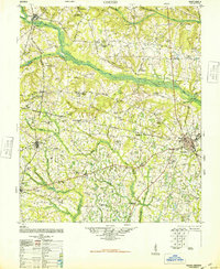
1948 Map of Gough
USGS Topo · Published 1948About this map
Brier Creek and its many tributaries, including Brushy Creek and Little Brushy Creek, carve a winding path through the agricultural landscape of Burke County in the late 1940s. The area is defined by a dense network of rural community centers, many established around combined institutions like Hopeful Church and School and Rocky Creek Church and School. The prominent Boggs Academy stands as a significant landmark for local education and social history near the center of the sheet.
Find a feature on this map
86 named features on this map. Tap any name to fly to it.
Don’t see what you’re looking for? This feature index may not catch every label — zoom into the map to look around manually.
Map Details
Editions of this 1948 Gough Map
2 editions found

Other maps of this area

1919 · Gough
USGS Topo · 1:62,500

1920 · Stapleton
USGS Topo · 1:62,500

1920 · Millen
USGS Topo · 1:62,500

1920 · Greens Cut
USGS Topo · 1:62,500

1921 · Augusta
USGS Topo · 1:62,500

1922 · Harlem
USGS Topo · 1:62,500

1922 · Hephzibah
USGS Topo · 1:62,500

1943 · Greens Cut
USGS Topo · 1:62,500

1943 · Millen
USGS Topo · 1:62,500

1943 · Augusta East
USGS Topo · 1:125,000