
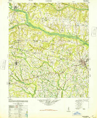
1948 Map of Gough
USGS Topo · Published 1948About this map
Brier Creek carves a broad valley through the center of this agricultural landscape in Burke and Jefferson counties during the late 1940s. The region is characterized by a dense network of country churches and rural education centers that served as the heartbeat of local communities. Significant landmarks include the Boggs Academy and combined institutions like St Clair Church and School and the Robertson Grove School and Church. The mapping reveals a transition in transportation, noting the presence of a Dismantled Railroad while the Savannah and Atlanta line continues to serve the settlements of Gough and Vidette.
Find a feature on this map
75 named features on this map. Tap any name to fly to it.
Don’t see what you’re looking for? This feature index may not catch every label — zoom into the map to look around manually.
Map Details
Editions of this 1948 Gough Map
2 editions found
Other maps of this area

1919 · Gough
USGS Topo · 1:62,500

1920 · Stapleton
USGS Topo · 1:62,500

1920 · Millen
USGS Topo · 1:62,500

1920 · Greens Cut
USGS Topo · 1:62,500

1921 · Augusta
USGS Topo · 1:62,500

1922 · Harlem
USGS Topo · 1:62,500

1922 · Hephzibah
USGS Topo · 1:62,500

1943 · Greens Cut
USGS Topo · 1:62,500

1943 · Millen
USGS Topo · 1:62,500

1943 · Augusta East
USGS Topo · 1:125,000