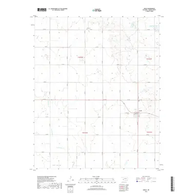
2018 Map of Gould
USGS Topo · Published 2018About this map
Gould serves as the primary settlement in this corner of Harmon County, situated along a grid of agricultural section roads including E1610 Rd and N1790 Rd. The landscape is defined by the drainage basins of Sandy Creek, with its East and West forks cutting through the southwestern plains. To the north, the terrain transitions into Star Valley, while small water bodies like Club Lake and the Tri-County Turkey Cr Site 3 Reservoir provide local water sources in an otherwise arid region. Genealogists will find the locations of Dryden Cemetery and Gould Cemetery particularly useful for tracing early residents. The town layout is clearly delineated with local streets such as Olney St and State St appearing near the town center.
Find a feature on this map
26 named features on this map. Tap any name to fly to it.
Don’t see what you’re looking for? This feature index may not catch every label — zoom into the map to look around manually.
Map Details
Editions of this 2018 Gould Map
This is the sole edition of this map. No revisions or reprints were ever made.
Other maps of this area

1955 · Lawton
USGS Topo · 1:250,000

1961 · Hollis
USGS Topo · 1:62,500

1971 · Russell
USGS Topo · 1:24,000
1971 · Mc Knight
USGS Topo · 1:24,000

1971 · Mc Queen
USGS Topo · 1:24,000

1971 · Duke SW
USGS Topo · 1:24,000
1971 · Shrewder
USGS Topo · 1:24,000

1975 · Hollis NE
USGS Topo · 1:24,000

1975 · Hollis SE
USGS Topo · 1:24,000
1975 · Hollis NW
USGS Topo · 1:24,000