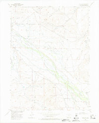
1955 Map of Gould NW
USGS Topo · Published 1975About this map
Manning Coal Mines and the Sudduth Coal Mine define the industrial footprint of this mid-century high-altitude landscape in Jackson County. The economy depicted here is a sophisticated marriage of mining and extensive water management, necessary for both resource extraction and ranching at these elevations. A dense network of irrigation channels, including Bostwick Ditch, Cleveland Ditch, and Curtin Ditch, web across the territory to redirect the flow of the Michigan River and its tributaries like Sage Hen Creek.
Find a feature on this map
49 named features on this map. Tap any name to fly to it.
Don’t see what you’re looking for? This feature index may not catch every label — zoom into the map to look around manually.
Map Details
Editions of this 1955 Gould NW Map
4 editions found
Other maps of this area

1954 · Craig
USGS Topo · 1:250,000

1955 · Eagle Hill
USGS Topo · 1:24,000

1955 · Gould
USGS Topo · 1:24,000

1955 · Owl Ridge
USGS Topo · 1:24,000

1955 · Shipman Mountain
USGS Topo · 1:24,000

1955 · Gould NW
USGS Topo · 1:24,000

1955 · Walden
USGS Topo · 1:24,000

1955 · Mac Farlane Reservoir
USGS Topo · 1:24,000

1955 · Kings Canyon
USGS Topo · 1:62,500

1955 · Walden
USGS Topo · 1:62,500