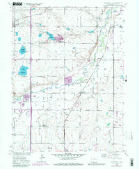
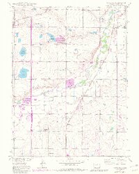
1949 Map of Gowanda
USGS Topo · Published 1983About this map
The agricultural landscape of Weld County is defined here by an intricate network of irrigation and water management, centered on the winding course of St Vrain Creek. The 1949 topography, later updated with aerial photography, reveals a rural society structured around local education and community hubs like Rinn Valley Grange. Smaller settlements like Mead, Gowanda, and Rinn are connected by the Union Pacific rail line, which cuts through a terrain dotted with essential water features such as Mulligan Reservoir, Foster Reservoir, and Lake Marie.
Find a feature on this map
20 named features on this map. Tap any name to fly to it.
Don’t see what you’re looking for? This feature index may not catch every label — zoom into the map to look around manually.
Map Details
Editions of this 1949 Gowanda Map
6 editions found
Other maps of this area

1902 · Greeley
USGS Topo · 1:125,000

1904 · Niwot
USGS Topo · 1:62,500

1906 · Loveland
USGS Topo · 1:62,500

1908 · Loveland
USGS Topo · 1:62,500

1949 · Gowanda
USGS Topo · 1:24,000

1949 · Fort Lupton
USGS Topo · 1:24,000

1949 · Platteville
USGS Topo · 1:24,000

1950 · Frederick
USGS Topo · 1:24,000

1950 · Gowanda
USGS Topo · 1:24,000

1950 · Platteville
USGS Topo · 1:24,000