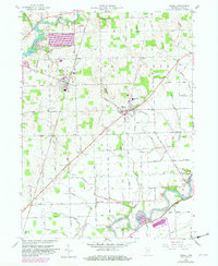
1958 Map of Grabill
USGS Topo · Published 1982About this map
The St Joseph River and Maumee River systems converge in this Allen County landscape, where the legacy of early Indiana transportation is clearly visible. The historic route of the Wabash and Erie Canal runs alongside the Maumee in the south, while the Norfolk and Western railroad serves the established communities of Grabill and Harlan. The map details a transition from the agricultural heartland to managed water resources, anchored by the St Joseph Cedarville Reservoir and its associated spillway.
Find a feature on this map
48 named features on this map. Tap any name to fly to it.
Don’t see what you’re looking for? This feature index may not catch every label — zoom into the map to look around manually.
Map Details
Editions of this 1958 Grabill Map
3 editions found
Other maps of this area

1953 · Fort Wayne
USGS Topo · 1:250,000

1956 · Fort Wayne
USGS Topo · 1:250,000

1956 · Fort Wayne East
USGS Topo · 1:24,000

1956 · Cedarville
USGS Topo · 1:24,000

1957 · Auburn
USGS Topo · 1:24,000

1957 · Maples
USGS Topo · 1:24,000

1958 · Hicksville
USGS Topo · 1:24,000

1958 · Grabill
USGS Topo · 1:24,000

1958 · Woodburn North
USGS Topo · 1:24,000
1958 · Saint Joe
USGS Topo · 1:24,000