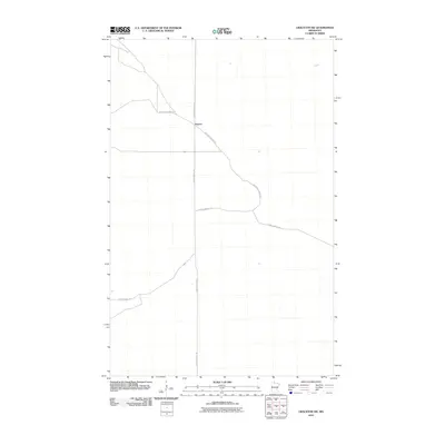
2010 Map of Graceton SW
USGS Topo · Published 2010About this map
Faunce occupies a central point in this remote section of Lake of the Woods County, where the settlement is defined by its position at a junction of forest roads. The landscape is characterized by a grid-like network of trails and routes cut through the northern woods, specifically Faunce Forest Rd and the diagonally-oriented Santa Ana Forest Rd. This area reflects a tradition of timber management and forest access, with named paths like Stony Corners Trl and Spina Forest Trl providing the primary infrastructure. The survey preserves the precise alignment of these backcountry corridors, such as Faunce-Butterfield Rd, which connect the isolated community to the broader region.
Find a feature on this map
6 named features on this map. Tap any name to fly to it.
Don’t see what you’re looking for? This feature index may not catch every label — zoom into the map to look around manually.
Map Details
Editions of this 2010 Graceton SW Map
This is the sole edition of this map. No revisions or reprints were ever made.
Other maps of this area

1918 · Winterroad
USGS Topo · 1:62,500

1918 · F
USGS Topo · 1:62,500

1919 · Peppermint Creek
USGS Topo · 1:62,500

1919 · G
USGS Topo · 1:62,500

1943 · Peppermint Creek
USGS Topo · 1:62,500

1954 · Roseau
USGS Topo · 1:250,000

1957 · Roseau
USGS Topo · 1:250,000

1958 · Roseau
USGS Topo · 1:250,000
1968 · Graceton SE
USGS Topo · 1:24,000
1968 · Graceton NW
USGS Topo · 1:24,000