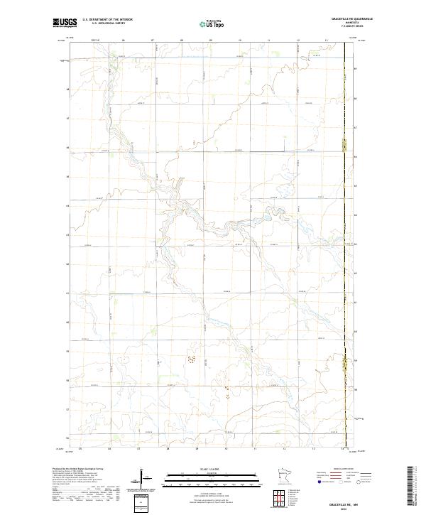
2022 Map of Graceville NE
USGS Topo · Published 2022About this map
The upper reaches of Twelvemile Cr define this agricultural landscape along the border of Traverse Co and Stevens Co. This modern survey illustrates the intricate drainage network of West Central Minnesota, where the W Fork Twelvemile Cr and E Fork Twelvemile Cr converge amidst a structured grid of rural roads. The area is heavily managed for water flow, as evidenced by the engineered path of County Ditch Number Eight in the northern townships. The map provides a detailed view of the Public Land Survey System divisions, specifically t126n r45w and t125n r45w, showing how the land has been partitioned for decades. While primarily open country, the map is a precise record of the current rural infrastructure, from Co Hwy 13 to the numerous section-line avenues like 770th Ave.
Find a feature on this map
37 named features on this map. Tap any name to fly to it.
Don’t see what you’re looking for? This feature index may not catch every label — zoom into the map to look around manually.
Map Details
Editions of this 2022 Graceville NE Map
This is the sole edition of this map. No revisions or reprints were ever made.
Other maps of this area

1910 · Chokio
USGS Topo · 1:62,500

1911 · Herman
USGS Topo · 1:62,500

1912 · Chokio
USGS Topo · 1:62,500

1950 · Graceville
USGS Topo · 1:62,500

1951 · Wheaton
USGS Topo · 1:62,500

1953 · Milbank
USGS Topo · 1:250,000

1958 · Milbank
USGS Topo · 1:250,000
1973 · Herman
USGS Topo · 1:24,000
1973 · Chokio NW
USGS Topo · 1:24,000
1973 · Chokio
USGS Topo · 1:24,000