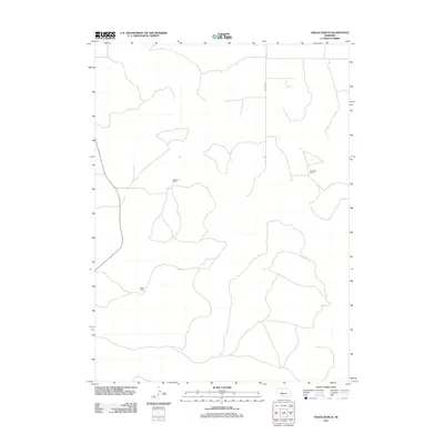
2011 Map of Gragg Ranch
USGS Topo · Published 2011About this map
The vast Nebraska sandhills of Lincoln County define the landscape of this 2011 survey, where large-scale ranching remains the primary footprint of human settlement. The territory is marked by significant properties including Stoddard Ranch in the northwest and Gragg Ranch further south. These family-named landholdings represent the enduring ranching economy of the Great Plains, where wide-open grazing lands are connected by a sparse network of paths and section roads. A north-south corridor provided by Ringgold Rd serves as a primary artery through this portion of the county, linking the widely spaced operations of Rundback Ranch and its neighbors. The contour work by the U.S. Geological Survey illustrates the subtle but complex elevation changes inherent to this prairie environment.
Find a feature on this map
4 named features on this map. Tap any name to fly to it.
Don’t see what you’re looking for? This feature index may not catch every label — zoom into the map to look around manually.
Map Details
Editions of this 2011 Gragg Ranch Map
This is the sole edition of this map. No revisions or reprints were ever made.
Other maps of this area

1899 · North Platte
USGS Topo · 1:125,000

1902 · North Platte
USGS Topo · 1:125,000

1949 · Cody Lake
USGS Topo · 1:62,500

1951 · Tryon
USGS Topo · 1:62,500

1951 · Cody Lake
USGS Topo · 1:62,500

1954 · North Platte
USGS Topo · 1:250,000

1956 · North Platte
USGS Topo · 1:250,000

1957 · North Platte
USGS Topo · 1:250,000

1967 · North Platte
USGS Topo · 1:250,000
1972 · North Platte 2 SW
USGS Topo · 1:24,000